
Marine GPS chartplotters help you navigate accurately and safely by providing real-time position updates, detailed electronic charts, and advanced features like route planning and hazard detection. They assist in avoiding shallow areas, rocks, and other hazards while offering tools for easier docking and maneuvering. By integrating radar, sonar, and AIS, they give you a complete picture of your surroundings, making your trips smoother and safer. Keep exploring to discover even more ways these systems can enhance your boating experience.
Key Takeaways
- Enable precise route planning and real-time navigation to avoid hazards and navigate complex waterways safely.
- Enhance situational awareness by integrating radar, sonar, and AIS for comprehensive environmental understanding.
- Assist in safe and accurate docking and maneuvering in tight or crowded areas.
- Improve trip management by marking waypoints, tracking progress, and exploring new routes efficiently.
- Increase safety through real-time alerts, hazard detection, and collision avoidance features.
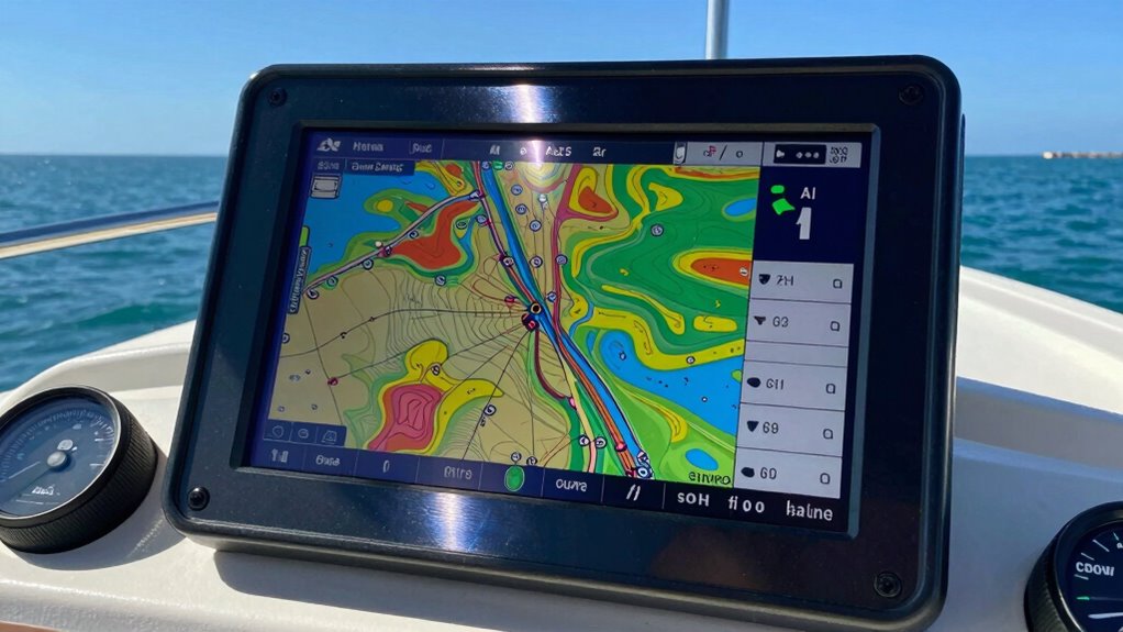
Using a marine GPS chartplotter, you can set a route and follow it precisely, which is especially useful for long passages or complex waterways. The electronic charting feature displays your boat’s position in real time, along with navigational aids, depth contours, and hazards, giving you an all-encompassing view of your surroundings. This level of detail allows you to plan your trip better, avoid shallow areas or rocks, and stay on course with confidence. You don’t have to worry about manually plotting your position or constantly checking paper charts; the chartplotter does all the work for you, providing a seamless navigation experience.
These devices also help you maintain situational awareness, an essential aspect of maritime navigation. If you’re cruising through busy channels or near other vessels, the chartplotter’s display can alert you to nearby traffic, helping you avoid collisions. Many models integrate additional features like radar, sonar, and AIS, creating an even more all-encompassing picture of your environment. This integration means you can see underwater structures, fish, or other vessels in real-time, further enhancing your safety and situational understanding. Electronic charting significantly improves your ability to navigate safely and efficiently. Additionally, real-time data integration allows for quicker decision-making in dynamic conditions. Incorporating marine navigation technology into your boat setup can greatly enhance your overall safety and confidence on the water.
Beyond safety, marine GPS chartplotters streamline your boating experience. They make docking and maneuvering easier, especially in tight spots or crowded marinas. By providing precise positioning, these devices reduce the stress and guesswork involved in complex maneuvers. Plus, they’re invaluable for trip planning, allowing you to mark waypoints, explore new routes, and keep track of your progress. This combination of electronic charting and real-time positioning transforms the way you navigate, making it more accurate, efficient, and safe.
In essence, marine GPS chartplotters give you the confidence and tools to navigate confidently in any maritime environment. They are indispensable for modern boat owners wanting to optimize safety, efficiency, and enjoyment on the water.

Simrad GO9 XSE Chartplotter and Fishfinder with HALO20 Radar, 83/200 Transom Mount Transducer and C-MAP Discover Charts, 9 Inch Screen, Black, 000-16294-001
MULTIFUNCTION DISPLAY: With GO9 XSE, add GPS navigation, sonar support, radar capability, and system integration to your boat—ideal…
As an affiliate, we earn on qualifying purchases.
As an affiliate, we earn on qualifying purchases.
Frequently Asked Questions
How Accurate Are Marine GPS Chartplotters in Different Weather Conditions?
Marine GPS chartplotters are generally accurate, but their performance can vary with weather conditions. Satellite interference from storms or heavy cloud cover may disrupt signal reliability, causing occasional inaccuracies. In clear weather, your chartplotter provides precise positioning, but in adverse conditions, expect some fluctuations. To guarantee safety, always cross-check your GPS data with traditional navigation methods, especially when weather impacts satellite signals and reduces overall accuracy.
Can Chartplotters Be Integrated With Other Onboard Navigation Systems?
Yes, chartplotters can seamlessly synchronize with other onboard navigation systems. Their integration compatibility allows you to connect with radar, sonar, autopilots, and AIS systems effortlessly. This system synchronization guarantees streamlined, safe sailing by sharing real-time data across devices. You’ll enjoy enhanced situational awareness, simplified controls, and smarter steering, making your voyage more secure and smooth. Embracing integrated navigation keeps you confidently charting your course through calm or challenging conditions.
What Is the Typical Lifespan of a Marine GPS Chartplotter?
A marine GPS chartplotter typically lasts around 5 to 10 years, depending on usage and maintenance. You should pay attention to battery life, especially if it’s a portable unit, and guarantee you keep up with software updates, which can extend its functionality and lifespan. Regularly replacing batteries and updating software helps you avoid outdated navigation data, keeping your boating trips safe and smooth.
Are There Options for Real-Time Weather Updates on Chartplotters?
Yes, many marine GPS chartplotters offer real-time weather updates through weather overlays, helping you stay informed about changing conditions. These features rely on data connectivity, allowing your device to access live weather information via satellite or internet. By integrating weather overlays, you can view storms, wind patterns, and precipitation directly on your chartplotter, enhancing safety and navigation accuracy during your voyage.
How Difficult Is It to Install a Marine GPS Chartplotter on a Boat?
Installing a marine GPS chartplotter might seem intimidating, but with user-friendly features, it’s often straightforward. You could face installation challenges, especially with wiring or mounting, but most models come with clear instructions and support. If you’re comfortable with basic tools and electronics, you’ll find the process manageable. Don’t rush—proper installation guarantees reliable navigation, turning what seems complex into a simple upgrade that keeps you safe on the water.

Rules of The Road Boating Navigation Chart #2 – Waterproof Quick Reference Guide – Essential Boating & Sailing Equipment – (Intercoastal and Inland) – Double-Sided & Easy to Read
Comprehensive Guide: Complete reference to essential boating safety rules and regulations with easy-to-understand instructions for emergency situations and…
As an affiliate, we earn on qualifying purchases.
As an affiliate, we earn on qualifying purchases.
Conclusion
With a marine GPS chartplotter, you’re not just steering—you’re enhancing safety and confidence on the water. Did you know that boat operators using GPS are 60% less likely to experience accidents? That’s a compelling reason to equip your boat with this technology. Whether you’re cruising or fishing, a chartplotter helps you stay on course, avoid hazards, and enjoy your time on the water more than ever before. Invest in one today and sail smarter tomorrow.
Lewmar 590006: Tt 185 3.0Kw 12V Gen 2
New
As an affiliate, we earn on qualifying purchases.
As an affiliate, we earn on qualifying purchases.

FIXED MOUNT VHF/GPS/AIS/NMEA2000
Reliable Fixed Mount VHF with NMEA2000, AIS and Internal GPS
As an affiliate, we earn on qualifying purchases.
As an affiliate, we earn on qualifying purchases.